What is the Scent Toolbox?
The Scent Toolbox is a set of smart technologies designed to engage citizens in environmental monitoring.
Why use the Scent Toolbox?
With the Scent Toolbox, you can use citizen science to collect up-to-date information about changes in the environmental, such as changes in land-cover/land-use, river parameters and soil conditions. All of this information is analysed by the Toolbox and used to help scientists and policymakers to create more accurate flood maps for the prevention of floods and other natural disasters.
Who is it for?
Anybody can use the Scent Toolbox. Public authorities can use the Toolbox to crowdsource information to make more informed policy-decisions concerning flood management and prevention. Communities and environmental groups can use the Toolbox to monitor changes in their local environment. Individuals can use the Scent Toolbox apps to have fun while also helping to protect the environment.

How does it work?

Scent Toolbox – Applications
Explore your surroundings with Scent Explore!
Scent Explore is an augmented reality game developed for the Scent project by XTeam Software Solutions.Learn more
Scent Explore invites you to discover your environment in an exciting way. Little Scent Explore characters are hiding in interesting places around you, and you collect points when you find them! Your smartphone or tablet will give an audio alert when you are approaching a character. To earn points, just tap on the screen to capture a character when you see it. Your camera will take a photo of the location and upload it to Scent. Compete with your friends and family and see who wins!
By playing Scent Explore, you make a valuable contribution to citizen science. You help researchers understand changes in the environment because all the locations in which you catch Scent characters contain interesting information that researchers will use to analyse and map the environment.
Join the Scent movement and become a citizen scientist today!


Scent Collaborate
Scent Collaborate is a browsing-based crowdsourcing platform developed by XTeam for the Scent project.Learn more
Scent Collaborate allows users to train and improve the Scent automated tools simply by browsing existing images and labelling them. Teaching the tools to identify pastures, forests, river banks, buildings, paved areas etc. will allow for more accurate mapping of the environment, which in turn will help predict and prevent flooding and other natural disasters.
You can access Scent Collaborate here:
https://scent-project.eu/scent-collaborate
The validation of the labels is supported by the Scent Captcha plugin that is embedded in the Scent Collaborate application. Scent Captcha plugin is distributed as an open source component, and can be embedded in third-party websites. The source code is available here
Scent Measure
Scent Measure is an innovative application developed by ICCS for the Scent project to measure changes in soil conditions. Learn more
Scent Measure is easy to use – simply insert the portable sensor into the soil, select whether to measure temperature or moisture, and receive the measures directly to your screen.
Scent Measure is triggered from Scent Explore app. When playing Scent Explore, you will be prompted to take a measurement at an important point of interest for scientists and researchers, and thereby contribute to monitoring and analysing your environment.
SCENT Measure application is released under an open source license and is available here
Scent Campaign Manager
The Scent Campaign Manager is a web-based application developed by ICCS for the Scent project, which allows public administrators, policy makers and other interested users to create and manage citizen science campaigns for monitoring and streamlining the collection of environmental information.Learn more
The Scent Campaign Manager allows users to select a specific area of interest to set up a Scent campaign. Citizens can then join the campaign by using the ‘Scent Explore’ and ‘Scent Measure’ apps to take photos of Land-Cover and Land-Use and gather important environmental information about the campaign area.
If you are interested in registering as a user and set up a Scent campaign in your city, town or urban area, please contact ICCS via email at: ScentCampaignManager@lists.scent-project.eu.
Scent Crowdsourcing Platform
The crowdsourcing platform is a key digital infrastructure of the Scent Toolbox, connecting all applications and services and orchestrating their functionality in a purposeful manner.Learn more
It acts as a central data broker that links the Scent frontend applications used by citizens to provide images, annotations, sensory data, event reports and videos, to all the other toolbox components.
The crowdsourcing platform allows local authorities to configure and manage crowdsourcing campaigns, define points of interest where pictures and measurements are needed, and monitor in real-time the pictures collected by citizens and the issues reported.
It also manages the complete lifecycle of citizen-generated images. Once a citizen takes a relevant picture using the Scent Explore app, the picture is sent to the crowdsourcing platform. It stores a copy of the image on the cloud and makes it available to the Scent artificial intelligence ‘heart’, also known as the Scent Intelligence Engine (SIE), which uses advanced machine learning techniques to automatically understand what is in the image. The annotations are fed back to the crowdsourcing platform, which is in charge of deciding whether the quality of the annotations is sufficient. If not, the image is made available for being further annotated, this time by people, through the CAPTCHA plugin or the Scent Collaborate app.
SCENT Measure application is released under an open source license and is available here.
Scent Harmonisation Platform
Considering the constantly increasing volume of citizen-generated data, it is of high importance to ensure that data of different origin are comparable and compatible, whilst facilitating their integration into models and the development of new applications.Learn more
To this end, data collected from citizens should be easily discoverable, accessible, re-usable and available for future use.
Scent meets these aspects of data interoperability through the development of a Harmonisation platform that enables the management, storage and provision of all citizen-generated data and added-value information produced by the various Scent tools (i.e. improved Land Cover / Land Use maps, flood risk maps) and translates them to standardised resources following the Open Geospatial Consortium (OGC) standards.
The Harmonisation platform implements also a Data Quality Control system aiming to cope with the following main challenges: correctness/accuracy of the user measurements, user reliability and protection of the system from malicious contributions. Finally, to achieve a maximum impact on scientific research and public policy, these resources will be also offered to the GEOSS portal and other relevant national repositories through a standardized way.
Scent Flood Models
The Scent Toolbox includes hydrodynamic and hydrological models that have been set up for the two pilot areas of Scent; the Danube Delta and the Kifisos catchment. Learn more
The models are computational representations of water dynamics in the pilot areas, and they are initially built using existing ground observations and remote sensing data.
After the Scent field campaigns, the models will be enhanced with crowdsourced data. The value of citizens’ contributions and their role in generating improved flood risk maps and spatiotemporal flooding patterns will be assessed.
The different characteristics of the two areas require different modelling approaches. In the Danube Delta, specifically in the Sontea-Fortuna pilot area, two hydrodynamic models were set up in order to simulate the complex network of channels and lakes in the area: one 1D model and one 1D/2D model.
In the Kifisos catchment, the pilot area is the upstream region of Athens city, where many hydrological components of the water cycle are more influent. A combination of models was therefore set up: a hydrological model connected to a hydrodynamic model at the end of the basin.
These models form a key component of the Toolbox as they serve as a basis for determining how they can be enriched through crowd-sourced data.
Scent Water Tools
Scent enables the collection of river measurements in a uniform way, which is useful to the development of flood models and invariant of the experience of the volunteers to collect the scientific data. Learn more
In order to properly collect river measurements, scientists use a variety of methods that require extended training and can be very time-consuming. To avoid that, the Scent volunteers are simply asked to take a picture of a water level indicator or a video of the predefined floating object and upload it through the gaming applications. The crowdsourced data is then forwarded to two tools that have been specifically designed to automatically extract the water level and the water velocity in a consistent and accurate way.
The water measurement tool uses state of the art image recognition techniques in order to extract the water level from images containing a water level indicator that is half-submerged into water. The goal of the tools is to ‘read’ the indicator and extract the number that is closer to the water level.
The water velocity calculation tool uses innovative video processing algorithms in order to extract the water surface velocity from a video containing a pre-defined floating object moving on the surface of a water body.
the water velocity calculation tool is available here and the water level measurement tool is available here.
Scent Map Segmentation Tool
Scent introduces novel machine learning approaches that automatically detect and annotate segments on satellite and aerial imagery, with land cover / land use (LC/LU) elements that affect flood risk and flood pattern determination (i.e. river banks, forests, buildings, etc). Learn more
Citizen-generated data are utilized for the training of the map segmentation tool, that aims to produce LC/LU maps of improved accuracy which are essential for the construction of hydrodynamic and hydrological models. These models are used to produce flood risk and pattern maps for urban and rural flood cases.
Last but not least, there is a prominent need to include automatic assessment and monitoring of land cover and state of soil in rural and urban areas as well as to detect seasonal changes, natural disasters, and human-related area development. Thus, the map segmentation tool aims to extend current repositories (i.e. GEOSS) by allowing for more frequent updates of local monitoring of land cover/use changes and with higher spatial resolution, using inexpensive crowd-sourcing tools.
Scent Intelligence Engine and Image Analysis Tool
SCENT studies the content of each image, uploaded by the citizens, looking for the information relevant to hydrodynamic modelling of the area. The type of ground cover or riverbank, presence and condition of water drains, and so on, can tell the experts much about the water behaviour in this area in the times of flooding. Learn more
SCENT platform is developed to gather thousands of images, sampling large of urban and nature areas, from the engaged citizens. Once the image comes in, we know where and when it was taken, and there is a piece of partial information on what’s in it, tagged by the author. However, the work only begins here. The Image Analysis Tool, powered by the cutting edge Computer Vision technology and brain-mimicking Deep Neural Networks, carefully analyzes the image, extracting semantic information. What kind of land cover is this – concrete, dirt road, or pasture? Is there buildings and cars or trees and riverbanks? And if there is a storm drain found, is it clean on clogged? All these findings provide important clues on how the water will behave in this area, enabling the hydrologists to make reliable predictions and to prevent casualties and damage.
How can I organise a Scent Campaign?
To organise a Scent citizen science campaign in your area email getinvolved@scent-project.eu. You can also check out the results of our pilot campaigns in Attica, Greece and the Danube Delta, Romania, here. We have also put together a training programme to help you use the Scent Toolbox to collect valuable environmental data.
Welcome Session
The Showcase was opened on 20 June by Eleni Velgaki, Director within the Region of Attica; Angelos Amditis, Scent Project Coordinator; and Izabela Freytag, EASME Project Advisor at the European Commission, who commended the project for making science and data accessible for all and for harnessing citizen science to make a positive different for the future.
Smart Technologies for Citizen-Driven Flood Monitoring and Management
“The data collected by citizens must be easy to find and accessible to support its future use”, said Valantis Tsiaskos, Scent Project Manager. The panel, also including Stefano Tamascelli, XTeam Solutions; Joseph Shtok, IBM Research; Ioana Popescu, IHE-Delft; and Valantis Tsiakos, ICCS, discussed how the Scent Toolbox technologies engage citizens in collecting information about the environment, and use machine-learning to transform this data into flood models and standardised resources.
Interactive Demonstration: The Scent Toolbox
Daniele Miorandi, U-Hopper, shared how the Scent Toolbox helps to gather citizen-generated data and translates it into resources to help policymakers make better decisions. Throughout the Interactive Demonstration, people could test out tools such as Scent Measure. Citizens use portable sensors together with Scent Measure to record and measure changes in soil conditions. Other Scent Toolbox components on display included Scent Campaign Manager, Scent Map Segmentation and Delineation, and Learn with Scent.
Roundtable: Challenges and Enables of Citizen Science in Flood Monitoring and Management 
Panellists discussed challenges and enablers of citizen science in flood monitoring and management. THe panel included researchers and policymakers from Greece and Romania, each bringing a new perspective to why people engage in citizen science and how to sustain that engagement. They were all in agreement that people need to see they are having an impact and can help by contributing to something greater. Izabel Freytag, from the European Commission, affirmed “There are many solutions and good examples. We can learn from other citizen science initiatives and educate people, starting with existing communities.”
Citizen Science Success Stories and Lessons Learned from Upscaling Such Initiatives
This discussion led into a session focused on success stories and lessons learned from other citizen science initiatives. Partners from LandSense, WeObserve Ecosystem, GROW Observatory, SMURBS, and HRTA from Scent each shared about how their projects have engaged citizens to become citizen scientists. Panelists were clear that data sharing is key to future developments in the field.
Field Trip to the Kifisos River Basin
On 21 June, participants were brought on a field trip to the Kifisos river basin, where participants were able to test the new Scent apps in a live Scent citizen science campaign. Participants were guided along the river bank where they used Scent Explore to gather data, such as land-use/land-cover images, water velocity measurements and river parameter measurements. Using the Scent Measure app and a portable sensor, the participants took measurements of soil moisture and air temperature at points of environmental interest. The information they gathered helps to create flood models for the river basin.
[ngg src=”galleries” ids=”5,6″ display=”basic_thumbnail” images_per_page=”16″ number_of_columns=”4″]
Presentations
Technical Posters
How to Participate
To enter, send a short description of your idea (1000 words plus any pictures, graphs etc) and a short biography (200 words) to appathon@scent-project.eu by 29 March 2019. If you are applying as a team, a representative should apply on behalf of your team, and include the names of all team members.
All entrants will receive feedback on the relevance of their submissions by 11 April 2019.
Selected participants will then enter the ‘rapid development’ phase where they will develop their proposed app in a one-month period. The deadline for submitting the final developed app is by 17 May 2019 at 00:00 CET. The apps should be submitted to https://isense-cloud.iccs.gr/s/Scent_Appathon.
The winner of the Appathon will be announced on 24 May 2019.
Participation in the Scent Appathon is subject to the attached terms and conditions.
The Prize
The winner of the Scent Appathon will be awarded the following prizes:
– The app will be included and promoted as part of the Scent Toolbox, making it available to an estimated 1500 currently registered users;
– The exhibition of the app at the Scent Showcase, 20 June 2019 in Athens, Greece (travel and participation costs will be covered by the Scent project);
– The demonstration and testing of the app in the final pilot campaign of the Scent project, 21 June in Athens, Greece;
– The usage of the app during the remaining Scent pilot campaigns to be organised in Athens, Greece, and the Danube Delta, Romania;
– Promotion of the app through the project website, social media and other communication activities, including a live broadcast of the app during the Scent Showcase and the featuring of the app on the WeObserve Website.

The Danube Delta, Romania

This is the largest wetland in Europe and is protected under UNESCO as a unique biosphere reserve. The Danube Delta suffers from human interventions leading to dramatic changes. These interventions include damming large areas for agricultural use and intensive forestry. They result in disturbances of the water and ecological balance and even the loss of specific habitats.
Kifisos River Basin, Attica, Greece

The Scent pilot in Greece relates to the urban environment around the Kifisos river in Attica. This covers app. 380km2, and almost 60% of its watershed is urbanised (metropolitan Athens area). Its hydrographic network has been drastically altered due to distinct land-use and 68% of the basin is occupied by urban expanses – host to 4 million citizens.
Scent 2018 Pilot Campaign Results

Scent Pilot Campaigns 2018 -2019

Project Objectives
- Design, develop and implement a people-centric observation web offered in the form of Open Geospatial Consortium (OGC)-compliant web services and resources to the GEOSS portal.
- Develop the innovative Scent crowd-sourcing platform to collect image as well as textual information from citizens; as a result, this will extend the in-situ infrastructure with citizen-sourced observations.
- Implement the Scent intelligence engine, which will use innovative machine learning techniques to classify and annotate images and text sourced from citizens as well as existing open platforms.
- Design and develop a serious gaming application to annotate unutilised images from popular open platforms, e.g. Flickr and Panoramio, as complementary data sources on land-cover and land-use changes.
- Quantify the impact of land-cover/use changes to flood risk maps and spatio-temporal flooding patterns.
- Design a simple authoring tool for policy makers to customise the Scent toolbox according to target group, regional or social characteristics.
- Test, evaluate and validate the Scent smart toolbox in two large scale pilots of great environmental impact; the urban case of the Kifisos river in Attica and the rural case of the Danube Delta.
- Increase the active engagement of citizens as individuals, citizen associations as well as local authorities in monitoring their environment through the creation of a citizen movement.
Methodology
The citizen-centric and participatory Scent methodology is divided into three phases:
- The requirements and architecture design phase includes a study and analysis of user requirements and needs for a sustainable and active citizen observatory.
- The technical development and innovation phase consists of the design, research, development and implementation of innovative tools and solutions that make up the Scent toolbox.
- The integration and large scale demonstration phase involves integrating the solution and ensuring through formal testing that Scent toolbox components are interoperable and fully functional. In this phase, two large scale pilots will be carried out to evaluate and validate the Scent citizen observatory.
Scent and the Open Research Data Pilot
Scent participates in the Pilot on Open Research Data launched by the European Commission along with the Horizon 2020 programme.
The Open Research Data Pilot aims to improve and maximise access to and re-use of research data generated by Horizon 2020 projects. It takes into account the need to balance openness and protection of scientific information, commercialisation and Intellectual Property Rights, privacy concerns, security as well as data management and preservation questions. While open access to research data thereby becomes applicable by default in Horizon 2020, the Commission also recognises that there are good reasons to keep some or even all research data generated in a project closed. The Commission therefore provides robust opt-out possibilities at any stage.
The Scent consortium supports open science and the large potential benefits to the European innovation and economy stemming from allowing reusing data at a larger scale. The majority of data produced in the project may therefore be published with open access.
The Scent Concept
Scent aims to demonstrate the huge potential of an active citizen observatory that will complement existing infrastructure through the Scent toolbox. It will lead to a significant pool of observations on changes in land cover and related environmental phenomena. Data will be fed via web services into existing repositories, such as the Global Earth Observation System of Systems (GEOSS) portal. Scent will provide policy-makers with a near real-time view of land-use changes while directly involving citizens in the decision-making process.
The Scent concept is built around three pillars:
Pillar I: Increased involvement of citizens in the process of land cover and land use monitoring through a set of participatory solutions
Pillar II: Better use of available data, repositories and monitoring systems through innovative tools and algorithms
Pillar III: Development of a co-design strategy, involving both citizens and public authorities with the aim of creating a sustainable citizen observatory
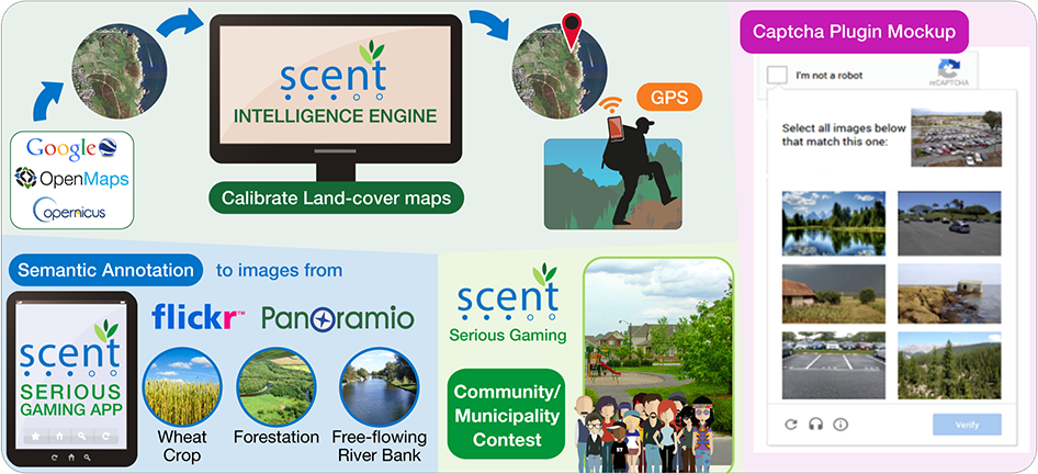
Illustration of the Scent Toolbox
Impact
The impact of the project will be felt in many ways, especially in the environmental, societal, technical and industrial field.
Environmental
Citizens often feel that their efforts won’t have much impact on environmental policies and climate change. Scent will show that citizens in fact can have a real impact in environmental monitoring and identification of flood risks.
Major environmental agencies and decision-makers have agreed to promote the project outcomes, which will guarantee EU-wide environmental impact.
Societal
Scent will foster innovation and create jobs in SMEs, which will help fight unemployment in Europe.
Scent will also improve the accuracy of existing flood risk maps by more than 15% and thus make areas close to floodplains less vulnerable to disasters.
Scent promotes an open method of coordinating environmental policies. It will include regional environmental groups, public-private partnerships and citizen communities in land-use monitoring, which will encourage innovative governance schemes.
Technical
Scent will bring about new technological developments and products through the SCENT toolbox, and citizens’ contributions to environmental data will be fed directly into the Scent intelligence engine. These will be key in generating precise and up-to-date land-use maps and flood risk maps for decision-makers.
Scent will also extend the GEOSS and Copernicus repositories through frequent updates of local monitoring of land-use changes using the Scent Toolbox.
Industrial
Scent will introduce low-cost state-of-the-art tools that will encourage further innovation and boost the development of new people-centric apps, products and services.
The Scent observatory will promote Europe in the global environmental monitoring market. Citizen engagement will foster the creation of new SMEs and boost innovation in current European SMEs. Scent will reveal an untapped potential for the gaming industry and the crowd-sourcing and social media industries to enter the environmental field.
Horizon 2020
 This project has received funding from the European Union’s Horizon 2020 research and innovation programme under grant agreement No. 688930.